What we know about the Oak Fire: Where it started, latest evacuations in California
The Oak Fire has been burning since Friday afternoon in the mountainous terrain of Mariposa County, about 14 miles from Yosemite National Park’s Arch Rock entrance on Highway 140.
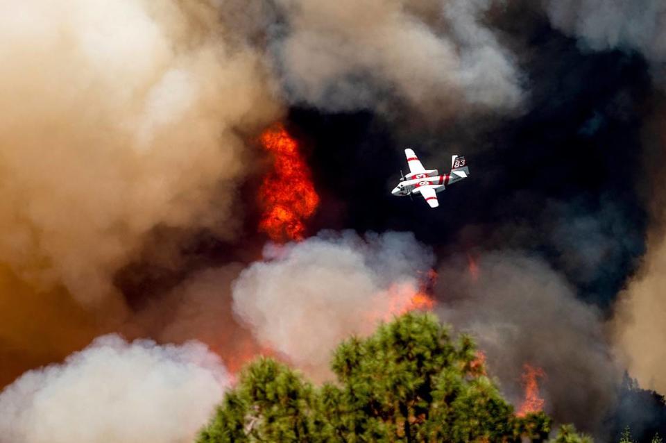
The Oak Fire had burned 15,603 acres and was 0% contained as of a 7 p.m. Sunday update, according to Cal Fire.

“The reason we’re still showing at 0% contained, there is hot ash, hot trees still throwing stuff over the line causing us concern,” said Mike van Loben Sels, Cal Fire Madera/Mariposa/Merced unit chief.
This is the third wildfire to burn this month in proximity to Yosemite and has proven to be the most challenging for fire crews.

The Washburn Fire and Agua Fire, which respectively started on July 7 and July 18, have reached near or complete containment as of Saturday. And neither of those wildfires grew larger than 5,000 acres.
Where did the Oak Fire start?
The Oak Fire ignited about 2:10 p.m. Friday in rural Midpines, near Highway 140 and Carstens Road. It’s about a 20-minute drive from Mariposa and an hour from Yosemite National Park.
The cause of the fire remains under investigation.
Full containment is not expected until at least July 30, according to Cal Fire.
Why is the fire spreading so fast?
Dr. Crystal Kolden, a pyrogeographer and a professor at UC Merced, posted on social media that the Oak Fire was expanding due to three primary factors: fuel load, heat and the very dry air due to Friday’s 108-degree conditions.
The professor said the area hasn’t burned since 1924.
Read more on the rapid spread at The Bee, Why is California’s Oak Fire spreading so fast? Here are factors experts say are at play.
Fire destroys, damages property
Cal Fire said the wildfire threatens 3,271 structures.
The Oak Fire is known to have destroyed 10 structures and damaged five others, Cal Fire reported.
When was the Oak Fire Town Hall meeting?
A Town Hall meeting took place at 7 p.m. Sunday at the Mariposa County High School gymnasium in Mariposa.
Key personnel provided updates, then took audience questions.
Evacuation orders, fire advisements
Multiple areas have been ordered to evacuate and other areas were placed under fire advisement, asked to be prepared to leave if necessary. Many roads in the area also have closed.
Thousands of people have been ordered to evacuate and power has been shut off to more than 2,000 homes and businesses.
Here are the fire advisement areas as of Sunday:
Highway 140 from Oak Road to East Whitlock
Oak Road from Highway 140 to Yosemite Oaks
Yosemite Oaks Road from East Whitlock Highway 140
Chamberlain Road
Allred Road from Morningstar to Highway 49S
Carlton Road from Morningstar to Highway 49S and all side roads
Highway 49S from Indian Peak to Triangle Road
Indian Peak from Highway 49S to Usona Road and all side roads
East Whitlock from Highway 140 to Yosemite Oaks Road
Stumpfield Mountain Road from Highway 49S to the Madera County Line, including all side roads
East Westfall from Oliver Creek to Chowchilla Mountain Road
Chowchilla Mountain Road from 49S to East Westfall
Ponderosa Subdivision, including: All of Chowchilla Mountain Road and all side roads; all of Harris Cutoff Road and all side roads; all of Harris Road and all side roads; 5S25 and 4S04; Highway 49S from Chowchilla Mountain Road to Harris Road on the Chowchilla Mountain Road side
Highway 49S from Triangle Road to the Madera County Line, including all side roads (this includes: Watt Road, Watt Road Extension, Harris Road, Kimble Road and all side roads)
Highway 140 from Ponderosa Way to Briceburg both side of the roads
Colorado from Highway 140 to East Whitlock
Rancheria Creek Road
Davis Road
Wilderness View Road
Rumley Mine Road
Grosjean Road from Highway 140 to Foran Road, including all side roads
Foran Road to East Whitlock
East Whitlock from Foran to Highway 140, including all side roads
Devils Gulch to Signal Peak Area, including Chowchilla Mountain Road
“A fire advisement is NOT an evacuation Order,” the Mariposa County Sheriff’s Office posted on Facebook, “it is simply to advise residents in the area of the potential need to evacuate should conditions change. Allowing those in the affected area to plan and prepare.”
An evacuation shelter has been established at Mariposa Elementary School, 5044 Jones St. in Mariposa.
Here are the mandatory evacuation orders as of Sunday:
Carstens Road
Buckingham Mountain Road
Plumbar Creek Road
Triangle from Highway 140 to Darrah
Jerseydale and all side roads
Lushmeadows Subdivision
Triangle Road from Darrah Road to Westfall and all side roads
Boyer Road from Highway 49S and all side roads
Darrah Road from Highway 49S to Triangle Road, including all side roads
Triangle Road from 49S to Westfall Road and all side roads, including Triangle Park
Tip Top Road
Wass Road
Westfall from Triangle to Oliver Creek
Silva Road from Cole to Triangle, including all side roads
Gingers Trish Road
Cole Road to Darrah Road, including all side roads
McNally Road
Highway 49S from Darrah Road to Triangle Road, east side only
Woodland Drive
Brooks Road
Carlton from Triangle to Morningstar Lane
Morningstar from Carlton to Allred Road, including all side roads
Indian Rock Lane
Allred from 140 to Morningstar
Westside of Highway 140 from Triangle Road to Allred Road
Carlton Road from Morningstar to Silvia Road, including all side roads
Silva Road from Carlton to Highway 49S, including all side roads
Shaffer Road from Silva Road to Allred Road
Highway 49S from Silva to Darrah Road (on the Bootjack Market side). To evacuate please use Carlton/Silva Road to Highway 49S
Highway 140 from Triangle Road to Ponderosa Way (on Midpines Market side of Highway 140)
Ponderosa Way from Highway 140 to Feliciana
Mountain Road and all side roads
Sweetwater Ridge/Mine area
Feliciana Mountain Road
Ferguson/Apperson Mine Road area
Savage Lundy Trail
Hites Cove Road
Footman Ridge Area
Devils Gulch area
Here are the road closures as of Sunday:
Highway 140 from Grosjean to Ponderosa Way
Carstens Road
Triangle Road from Highway 140 to Highway 49 and all side roads
Jerseydale Road
Silva Road from Cole Road and Triangle Road
Wass Road
Tip Top Road
Darrah at 49
Westfall from Triangle to Oliver Creek
McNally Road
Woodland Drive
Brooks Road
Bootjack Lane
Cole Road
Carlton from Triangle to Morningstar
Allred from Highway 140 to Morningstar
Morningstar from Carlton to Allred, including all side roads
Have animals needing evacuation?
The Mariposa County Sheriff’s Office said large animals could be housed at the Mariposa Fairgrounds, 5007 Fairgrounds Road, Mariposa.
However, no visitations of your animals are allowed at this time.
In addition, large animals could be taken to the Coarsegold Rodeo Grounds, 44777 Rodeo Grounds Lane.
For those who need to drop off food or “for specific information about your large animal, NOT Dogs or Cats,” contact Animal Control at 707-484-3556.
The small animal drop off at the Mariposa County SPCA was full.
But small animals still were being accepted at Mariposa Elementary School, 5044 Jones St., Mariposa.
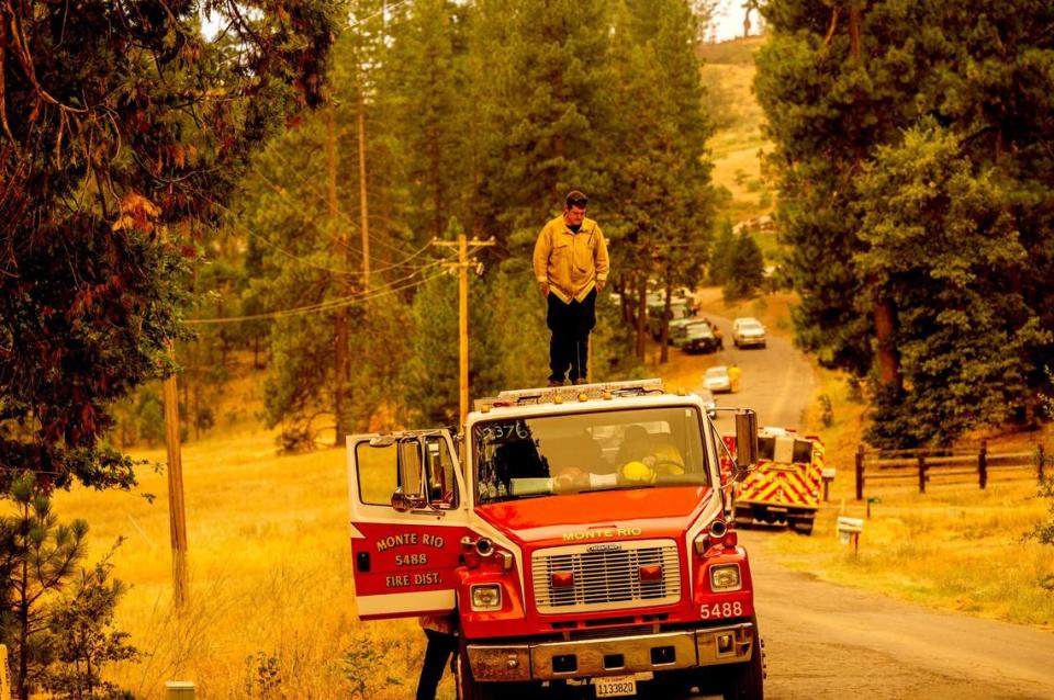
How many firefighters are battling Oak Fire?
By Sunday night, a total of 2,548 personnel were batting the fire.
There were 281 engines, 86 dozers, 63 hand crews, 46 water tenders and 17 helicopters.
State of emergency
On Saturday evening, Governor Gavin Newsom declared a state of emergency for Mariposa County.
A state of emergency allows public officials to change usual operations and order actions to respond to an unfolding crisis.
Earlier Saturday, Newsom announced that California secured a federal grant that will provide financial assistance in the fight against the Oak Fire.
The Fire Management Assistance Grant comes from the Federal Emergency Management Agency (FEMA).
Where has the fire spread lately?
“On the north side, the fire passed Sweetwater Ridge and made a hard push toward the community of Mariposa Pines,” Cal Fire stated in its Sunday night update. “Three strike teams were able to hold the fire at Bear Clover Lane, protecting Mariposa Pines.
“The fire perimeter is moving into the Ferguson Fire burn scar in the northeast side. Damage inspection teams began surveying the (affected) areas.”
Where to find Oak Fire updates
Follow The Bee’s coverage of the Oak and other wildfires at fresnobee.com/fires. Recent stories include:
»» Oak Fire live updates: ‘Extreme’ wildfire surpasses 15,500 acres, crews race to halt spread
»» Why is California’s Oak Fire spreading so fast? Here are factors experts say are at play
»» Oak Fire prompts Newsom to declare state of emergency for county near Yosemite National Park
»» Fast-moving Oak Fire near Yosemite is belching smoke. Will it choke Fresno area?
Sign up for text and email alerts, including evacuation orders, from the Mariposa County Sheriff’s Office at MSOAlert.com.
Cal Fire’s incident page for the Oak Fire is at fire.ca.gov/incidents/2022/7/22/oak-fire/. Updates are also posted on the agency’s Twitter account @CAL_FIRE. A comprehensive release describing overnight activity and the forecast for the day is typically posted by about 7 a.m.
For real-time air quality conditions generated by sources including wildfire smoke across the country, visit fire.airnow.gov.
Unofficial but generally reliable updates are posted at @CAFireScanner.
The Fire Integrated Real Time Intelligence System (FIRIS), “a program intended to significantly improve situational awareness for first responders,” posts the latest mapping and acreage totals @FIRIS.
Updates and retweets with key context can be found @stacey_hb_.
What they’re posting on social media about the Oak Fire
This hour on #OakFire 10am Sunday. Camera view looking N with smoke generally drifting North. @AlertWildfire #cawx #wildfire pic.twitter.com/ans9bD1bMK
— craig philpott (@CphilpottCraig) July 24, 2022
UPDATE: Our home stands! #OakFire.
Can't express my appreciation for the outpouring of prayers, concern, & offers to help if we need help.
Some have lost everything-This fire isn't done by a long shot.#Firefighters/1st responders ONLY RESPECT!
Picture-
Friday as we evacuated. pic.twitter.com/cNRFfgflX3— Arianne (@ravensspirit68) July 24, 2022
This smoke projection from the High-Resolution Rapid Refresh computer model depicts heavy smoke from the #OakFire moving westward over Yosemite National Park this afternoon. Downslope winds will push heavy smoke into the Sierra Nevada foothills tonight. #CAwx #Firewx pic.twitter.com/ys3ZliOc0e
— NWS Hanford (@NWSHanford) July 24, 2022
Yesterday I thought I was going to have to evacuate and had the car packed up. But then the big jets arrived! Heroes! #oakfire pic.twitter.com/XmOeS4ah1D
— Beth Pratt (@bethpratt) July 24, 2022
Here is a view of the Oak Fire activity on Jerseydale rd near the Forest Service Station. The fire has burned 14,281 acres as of this morning. Today will be another tough day of operations for all resources.to the individual who sent this in to us #oakfire #California #mariposa pic.twitter.com/pjXOUFARJq
— TheHotshotWakeUp: Podcast (@HotshotWake) July 24, 2022
Surreal apocalyptic scene from the #OakFire pic.twitter.com/ylTyJgoLhb
— Technically J (@Technically_J) July 24, 2022
With the #OakFire burning within the thermal belt in the Mariposa foothills, very low relative humidity of 10-15% is allowing for the fire to remain active at this hour. Latest radar echo tops are still around 15kft. #cawx pic.twitter.com/NTpgGbC5ie
— NWS Hanford (@NWSHanford) July 24, 2022
I really wish this thing would lay down & take a nap.
Mt. Bullion 2 Cam#OakFire #Midpines #Mariposa #MariposaCounty pic.twitter.com/CTU3Myspj5— Tay Austin (@Jasamsdestiny) July 24, 2022
Some night shots of #fireview scanning the #OakFire right now. pic.twitter.com/LAwdRG9KSx
— Courtney Aviation (@CourtneyAviati1) July 24, 2022
Warm, dry nights esp along the ridges like this can lead to some 24 hour fire cycles… based off the @AlertWildfire cams and radar that’s looking to be the case on the #OakFire Saturday night #CAwx 7/23/2022 pic.twitter.com/HHTzUlwTq8
— Rob Mayeda (@RobMayeda) July 24, 2022

