These are 6 of the worst floods in Sacramento history. One made an ‘inland lake’ to the Sierra
The capital region has faced a series of brutal storms since New Year’s Eve, which have flooded homes, cut power to thousands of families and killed five people in Sacramento County alone.
California has sought to control its rivers for 173 years, and the storms will only get worse: The Department of Water Resources has acknowledged that climate change has intensified the risk of flooding in the Central Valley. The state and federal government have built levees and dams, but the possibility of a major flood remains.
Here are some of the worst storms to hit the Sacramento area since John Sutter showed up.
The flood of 1850 ushers in a new mayor
Non-native people had virtually no experience in the Central Valley until the summer of 1839, when John Sutter arrived in what is now Sacramento.
The valley can turn into an inland sea, which Sutter learned from Maidu and Miwok people he pressed into labor; they recommended building the Swiss settler’s fort on a hill.
As the Native people predicted, the fledgling city of Sacramento flooded in 1850, prompting a candidate for mayoral office, Hardin Bigelow, to run on a platform of building levees. He won the race to become the first elected mayor of Sacramento, and he immediately started construction.
Ultimately, the city built nine miles of levees, which were, according to the KCRA documentary “To Conquer the Inland Sea”, between three and six feet high on average.
Storms in 1852 showed the city how little the rivers cared: The levees failed, and the city flooded again. In 1853, Sacramentans rebuilt the city — right on top of the old buildings.
Where could Sacramento County flood? This interactive map shows risk areas
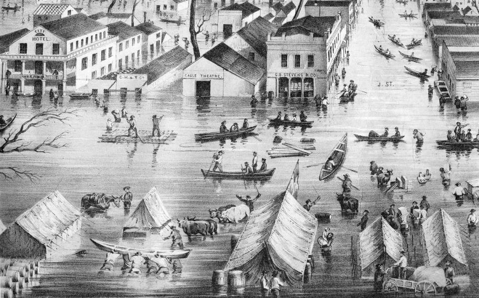
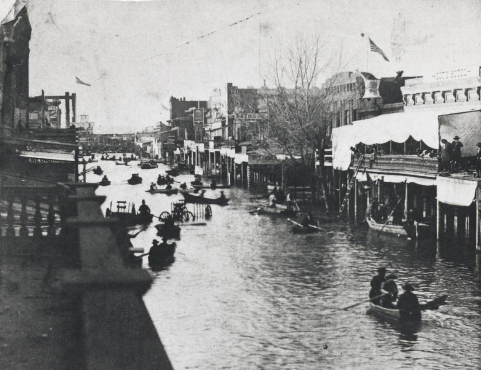
The Great Flood of 1862 kills thousands
The inland sea arrived again when extremely heavy rains hit the region in the winter of 1861-1862 and created a body of water that stretched across the Central Valley.
According to the Jan. 2, 1862 edition of The Sacramento Bee (then The Daily Bee), in December, “The whole city was submerged, with the exception of Front and I streets.” The city then flooded again in January.
The settler John Carr described the Sacramento River during the 1862 flood in his 1891 book, “Pioneer Days in California”: “During one of its highest stages, I was a passenger on the old steamer ‘Gem’ from Sacramento to Red Bluff,” Carr wrote. “The only way the pilot could tell where the channel of the river was, was by the cottonwood trees on each side of the river. The boat had to stop several times to take men out of the tops of trees and off the roofs of houses.”
A seismologist at the U.S. Geological Survey told ABC in 2020 that the storms in the winter of 1862 killed 4,000 people. The city of Sacramento was inundated, to the point that the Legislature moved to San Francisco for the 1862 session.
After that flood, the city straightened out “problem spots” at the confluence of the American and Sacramento rivers, inspiring, once again, confidence that new protections would save a city built in a floodplain.
In March 1907, 11 levees broke between Colusa and Grimes alone, and in 1908, the Sacramento Valley flooded again. Eventually, Congress approved the Sacramento River Flood Control Project in 1917. One of the earlier pieces of flood infrastructure built by the project was the Fremont Weir. Since 1929, the weir has directed overflow from the Sacramento River into the Yolo Bypass, diverting some waters before they hit the city.
1955 floods kills more than 60 people
A series of storms swept through Northern California from Dec. 16 through Dec. 29, 1955. Sacramentans, confident that the Shasta Dam newly completed in the 1940s would protect the city from floods, actually built homes on the river side of the levee (yes, the river side of the levee) by Garden Highway.
The people in these homes, The Bee reported at the time, evacuated during the ’55 storms because the Shasta Dam, of course, did not protect houses right next to the river. Meanwhile, Morrison and Elder Creeks overflowed.
On the 20th, The Bee wrote, “a fierce storm which set a December record for rainfall in Sacramento” had already killed two people in other counties — a driver died when the Eel River flooded, and a farmer died trying to ride his horse across a flooded road near the Russian River.
The Bee reported on the 22nd that Folsom Dam was credited with stopping the American River from overflowing in the city. But warm rains continued falling on the snow pack in the Sierra, sending more runoff into the Valley.
Levees broke on the Feather River, leading to the evacuation of Marysville; Isleton was also evacuated. By Dec. 27, South Sutter County had turned into a lake. According to the KCRA documentary, 100,000 acres were inundated.
Ultimately, more than 60 people died; The Bee reported that at least 42 people died in the areas around Yuba City and South Sutter County. The Natomas Cross Canal almost had a storm breakthrough.
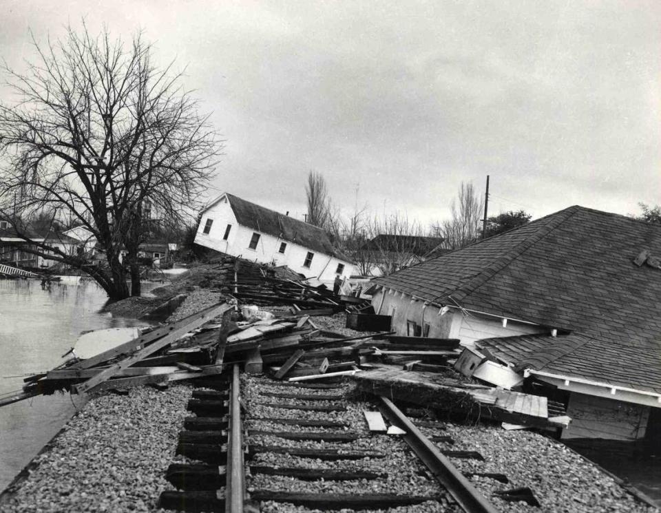
1964 Christmas flood: ‘This is a major American disaster’
Three storms between Dec. 19, 1964 and Jan. 31, 1965 hit the much of the West Coast — a Pineapple Express dumped relatively warm rain on snow. On Dec. 21, 1964, The Bee reported, “Water rose rapidly on the Feather, Yuba and American rivers flowing out of the Sierra today, but forecasters said there is no danger of flooding or property damage.”
A front-page headline on Dec. 23 said, “Peril Of Major Flood In Valley Is Discounted.” According to a Department of Water Resources bulletin, 375,000 acres in the Central Valley flooded.
The Bee reported that the boat launch at the new Discovery Park had been swallowed by the river; Miller Regional Park was underwater; and the partially completed Hell Hole Dam in Placer County collapsed, meaning it would shoot 30,000 acre-feet of water into Folsom Lake. A levee just downstream from the H Street Bridge came close to breaking.

An extra edition of the Humboldt Standard reported on Dec. 23 that this was a thousand-year flood: “A vast inland sea of flood waters covers southern and western Humboldt County today.” Multiple towns in Humboldt County were literally gone. Notably, the state was saved in large part due to the efforts of 1,200 imprisoned Californians, who served as emergency workers.
Flood controls implemented since the 1955 storms kept the capital fairly safe, though aerial photos from the time show the Sacramento River close to level with the Tower Bridge. Sacramento saw about 20 inches of rain in three days. Then-Gov. Edmund G. “Pat” Brown said, “This is a major American disaster.”
1986 flood hits Arden Arcade
In January of 1981, the Associated Press reported, “Reclamation districts say they are running out of money to maintain levees.” The AP quoted reclamation district engineer George Raab, who said, “We’ve been applying a Band-Aid approach since the things were built…From the local standpoint, we cannot justify the expenditures necessary (to prevent flooding). The money just isn’t there.”
Five years later, at least seven people were killed in a string of Northern California February storms during another atmospheric river event.
Nine and a half inches of rain fell in the capital over the course of eight days. Some 1,200 residents evacuated their homes when Arden Creek broke through a levee in Arden Arcade during a February storm. On Feb. 18, The Bee quoted Marjie Lambert, who owned a flooded condo at Howe and Northrop avenues: “It’s up to my hips when I’m downstairs,” she said. “Our sofas are floating.”

During the storm on Feb. 18, a tornado touched down in Orangevale and destroyed two sheds and tore up the roofs of three homes.
By Feb. 19, The Bee reported, a cofferdam broke near Auburn, which caused 100,000 acre-feet of water to bring Folsom Lake within two inches of spilling over the dam. Arden Creek overflowed near American River College. By Howe Avenue between Northrop Avenue and Sierra Boulevard, 160 homes flooded with anywhere from 6 inches to 4 feet of water. The Los Angeles Times said that near Walnut Grove, the Mokelumne River broke through a levee, rushed into homes and inundated farms. Other parts of the region flooded too, including Olivehurst (which, incidentally, used to be partially at the bottom of a lake).

Rivers ‘explode’ in the Central Valley in 1997
Multiple rivers flooded surrounding communities in the Sacramento Valley during storms in early 1997. “Fueled by unceasing rains and snowmelt, the Cosumnes River exploded over its banks and through a series of levees (the morning of Jan. 2) to flood dozens of homes and force the evacuation of at least 15,000 residents throughout southern Sacramento County,” a Bee story on Jan. 3 began.
During the same Jan. 2 deluge, 50,000 residents in Marysville and Yuba City were ordered to evacuate as levees on the Feather River threatened to buckle. The Tuolumne River overran Modesto. By Jan. 5, President Bill Clinton had declared a state of emergency, and The Bee reported that 125,000 people across the state had been displaced and at least three people had died in the storm.