How one Cathedral City neighborhood was destroyed by Tropical Storm Hilary

Rick Ravanello was trapped on his front porch the night Tropical Storm Hilary flooded his street in Cathedral City with an unprecedented amount of water and mud.
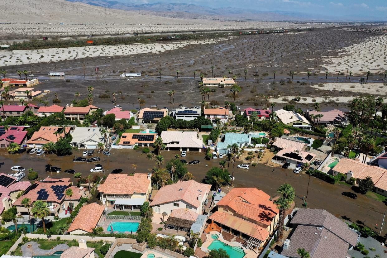
Horizon Road, located in the city’s Panorama neighborhood, is in a flood zone. But on the night of Aug. 20, residents were surprised that mud was rapidly filling the street along with rainwater.
It was like a culvert, Ravanello said. The actor has lived on Horizon Road for around nine years, but said he hadn’t seen anything like it. He was stuck on the porch after checking on his garage for several hours before the water receded sometime around 4 a.m. and he could make his way inside.
“I’ll never forget it for the rest of my life,” Ravanello said.

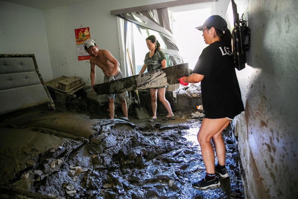
He and his wife lost six pets – some of them were still trapped in mud days after the storm. He injured his leg. At least 3 feet of mud caked the inside of their home, burying furniture and limiting pathways. Their pool was buried in it. It smelled like sewage.
The place Ravanello called his dream home was now unlivable.
Tropical Storm Hilary did not impact any other residential area in the Coachella Valley as intensely as Horizon Road. First-responders rescued 14 seniors from a home care facility on the street the day after it hit. City officials estimate that around 25 homes were affected by mud.
The street’s location in a high-flood risk area, combined with historic rainfall and unexpected mudflows, made it particularly vulnerable to disaster. And given where growth is booming in the valley, and the increasing occurrence of extreme weather events like Tropical Storm Hilary, there is a high likelihood that something like this could happen again – on Horizon Road or elsewhere.
Horizon Road homes have always been at risk of flooding
Flooding in the Panorama neighborhood wasn’t completely unexpected. The northeast corner of the neighborhood, encompassing roughly 60 homes out of approximately 1,300 in the square neighborhood bound by Vista Chino, Landau Drive, 30th Avenue, and Date Palm Drive, falls into FEMA’s high-risk flood zone. The homes are mapped as “Zone A,” which designates areas with a 1% annual chance of flooding and a 26% chance of flooding over the span of a 30-year mortgage. Homeowners in Zone A with a federally backed mortgage are required to carry flood insurance.
“The obvious reason (for the flooding) is topography. Everything drains in that direction,” Coachella Valley Water District engineering manager David Wilson said.

Just north of the homes on Horizon Road is the Morongo Basin watershed, a 200-square-mile watershed that is usually a dry desert landscape, but during storms carries water from the Mission Creek area through a wide drainage area north of Interstate 10. It filled with a huge amount of water from Tropical Storm Hilary – rainfall along the eastern slope of San Gorgonio, which drains into the Morongo watershed, translated to a 1 in 1,000-year flood event, according to Cathedral City Public Works Director John Corella.
A combination of El Niño and human-caused climate change created the hot air and hot ocean conditions that fueled Hilary. Palm Springs, which averages 4.61 inches for the entire year, saw 3.23 inches of rain in one 48-hour period during the storm.
A combination of the sheer volume of water that fell during Tropical Storm Hilary and the amount of mud and debris flows contributed to the damage on Horizon Road.
“(The mud) causes displacement for water and causes it to spread out even more, and then with the intensity we received with that volume of rain, the ground just does not have the capacity to soak it in, so that water’s going to flow and any loose debris you have is going to go right on with it, adding to the magnitude of the problem,” Wilson said.

Satellite photos of the flooding show the water and mud flow running parallel to the railroad tracks and Interstate 10 before veering southeast at Date Palm and down into the Panorama neighborhood. It appears like the volume of mud and water was too much for the culvert under Interstate 10 at Date Palm, causing the flow to turn toward the Panorama neighborhood.
“We had as much as nine inches in six hours over the Mission Creek area,” Wilson said. “It was an unprecedented storm event. And that coupled with all the debris and mud flow created a problem for any infrastructure that was out there, the culverts under the 10 are just not sized for that volume."
Cathedral City officials say the flooding largely stayed within the small corner of the community that is mapped in the flood zone, and believe that there might have been less damage if only water, not mud, flowed through the community.

“If it had only been water, that still would have been something to deal with, but it would have been a different story than the fact that it was this mud flow,” Cathedral City Manager Charlie McClendon said.
The mud flowed “kind of like lava, pulling in and pushing back,” said Corella, while when water flows through that neighborhood it typically moves through at a faster velocity before crossing under Date Palm and eventually flowing out onto open land on the east side of the street.
City officials are still looking into why Hilary brought so much mud into the community.
“The flood zone was something that was known, what I think no one expected was the possibility of mud coming down and maybe clogging up some of the designed flow paths, causing them to back up and flow into this neighborhood,” said Brett Sanders, professor of civil and environmental engineering at UC Irvine. Sanders says the mud could have resulted from the intensity of the rainfall, which can mobilize more sands and turn into a mudflow.
Neighborhood is unprotected from stormwater flows
If those same homes on Horizon Road were built in the same place today, the city would have required that the homes be built on raised pads that elevate them out of the flood zone, according to Corella. But that wasn’t a requirement when most of the homes in the neighborhood were built back around the 1980s. Instead, the homes in the upper corner of the Panorama neighborhood were built in the floodplain with little protection. And they’re not alone – pockets of other neighborhoods near Interstate 10 are also mapped in Zone A. The Rio Vista neighborhood in Cathedral City, Thousand Palms, and Talvera in Indio are all also in Zone A, along with many other communities in the Coachella Valley.
“In general terms, there’s a couple of solutions for a community facing high flood risk like this,” said Nicholas Pinter, a professor of applied geosciences and associate director of the Center for Watershed Sciences at UC Davis. “And one is either to not build stuff in the path of the flood in the first place, or you engineer protections afterward.”
Horizon Road and other communities along the flood zone near Interstate 10 are currently without flood protection, although the Coachella Valley Water District is currently working on three projects that would provide engineered protection from flooding.


Most of CVWD’s existing stormwater protection and flood control facilities were built in the 1970s following severe flooding brought on by Tropical Storm Kathleen and other storms. These facilities are largely concentrated in the cove communities of the Coachella Valley, since most development at the time was in that area.
Stormwater infrastructure generally follows development, and with the high price tag of these types of projects, CVWD is just starting to catch up on flood protection infrastructure to the development that’s popped up around Interstate 10 over the past few decades.
This June, CVWD completed the environmental reviews for the North Cathedral City Regional Flood Control Project, which is intended to capture some of the flows that descended on Horizon Road during Hilary and direct the runofff to the Whitewater River/Coachella Valley Stormwater Channel. It's a 50-mile storm channel that runs from the Whitewater area to the Salton Sea and serves as the backbone of the Coachella Valley’s stormwater protection. Currently, there isn’t any facility that would capture those flows from the Morongo Basin watershed and direct them to the stormwater channel, leaving the water free to flow and spread across communities like Horizon Road.

The roughly 26-acre project site is located about 130 feet southwest of Interstate 10 and a little less than a mile east of Gene Autry Road. The project would convey stormwater flows from north of the Union Pacific Railroad tracks south under the tracks, then southward to the Whitewater River Stormwater Channel. Currently, stormwater flows become trapped between the railroad tracks and Interstate 10, causing flows downstream to the southeast and toward residential communities.
CVWD hopes to put that project out to bid next year, and then construction will take between six and nine months, according to Wilson. The project is expected to remove some Cathedral City homes from the FEMA flood map. The project would capture “roughly half of the flood flows coming out of the Morongo Basin,” according to Wilson. The other half of flows would be addressed through Phase 2 of the project, which would involve building a bridge on Interstate 10 and is “many years out” with a price tag of $300 million.

The North Cathedral City Project is one of three connected CVWD projects intended to reduce flood risk for communities just north and south of Interstate 10. The Thousand Palms Flood Control Project will build a series of levees in the Thousand Palms area to catch flows coming out of the Thousand Palms watershed. That project has a $120 million price tag and requires the acquisition of 500 acres of land, and CVWD is still looking into funding options and options to build the project in phases, according to Wilson.
A third project, the North Indio Regional Flood Control Project, is under construction with an expected completion date sometime next year. That project will connect two existing flood control channels in Sun City Palm Desert and Sun City Shadow Hills, protecting homes in North Indio from flooding and eliminating the need for flood insurance in that area. Combined, the three projects – North Cathedral City, Thousand Palms, and North Indio – will help direct water flows from the open desert wash north of Interstate 10 through designated channels into the Whitewater River Stormwater Channel, which terminates at the Salton Sea.
Flooding is possible throughout the Coachella Valley
Once all those projects are completed, flood risk will persist. Flood experts note that predicting flooding in desert systems like the Coachella Valley is notoriously difficult. This is because of alluvial fans, fan-shaped deposits of sediments that are often found in deserts, created by water flowing through a narrow gap in the hills or mountains and onto the flat desert landscape.
Rivers typically follow a set path over time, making it easier to predict where water might go during a flood event. But desert drainage systems are different. The path water takes down an alluvial fan and through a desert drainage can jump around and change, making the path harder to model and predict.

“With alluvial fans, the water will make its own watercourse, it won't move down where it went last time, it'll find new ways,” said FEMA spokesperson Frank Mansell. “It's kind of like spraying Windex on a windshield or a piece of glass. You have no idea what path that water is going to take to get to the bottom of the window. And that's what alluvial fans are and that's the Coachella Valley, all alluvial fans with a broad valley in the middle.”
And neighborhoods like Horizon Road and others that are built right along the northern edge of development in the Coachella Valley, either adjacent to these drainages or built right on the floodplain, are in the path of these unpredictable flows.
Another complication with flooding in desert washes is that there aren’t consistent low flows to remind residents that they’re living in a drainage pathway, says Sanders.

“In other places where it rains more frequently, and there's always a little bit of flow in the stream, you have an indicator that there is a flow path, in your community because you see the water flowing. You suppose if it rains really hard, there might be more water flowing there,” Sanders said. “But if what you see on a regular basis is just a desert wash with no water, then you might conclude that there’s not a whole lot of reason for you to think that there’s a flood risk.”
Even neighborhoods outside of FEMA’s identified flood zones aren’t necessarily immune to flooding, as also demonstrated by Tropical Storm Hilary. Palm Desert’s Spanish Walk neighborhood, wedged just below Interstate 10 east of Gerald Ford Drive, also was hit hard by flooding from an overflowing drainage channel, forcing the evacuation of residents from their homes. The neighborhood was impacted even though it’s not in FEMA’s flood zone.

As much as 40% of insurance claims under the National Flood Insurance Program are for properties that fall outside of FEMA’s identified flood zones, according to Mansell, who added that just 1 inch of water in a home can cause $25,000 in damage.
Current FEMA flood maps for the Coachella Valley area are also from 2008, and likely based on data from about five years prior, Mansell said.
“People plan based on the FEMA maps, that’s really often all municipalities have to go by, so they plan based on those lines,” Pinter said. “But it’s well-known that those are representing today’s, if not yesterday’s flood boundary, and not what it actually is today, and certainly not what it will be in the future as a result of climate change.”
Mansell says all of this means that “flood insurance is always a good option to consider,” even for those living outside of identified flood zones.

“As much as our maps are the best that they were at the time that they were produced, that doesn't negate the fact that Mother Nature has better ideas or doesn't read our maps,” said Mansell. “Everybody’s in a flood zone.”
How Cathedral City prepared for the storm, and responded
Cathedral City, expecting just rain to impact the community, made preparations for the storm that included distributing sandbags, clearing storm drains on public streets and having extra staff on hand, according to McClendon.
There were no fatalities or serious injuries, but the mud posed a major challenge for helping residents. Assistant City Manager Anne Ambrose said additional resources like the Palm Springs Fire Department were called to help.
“The mud made it, particularly up in the far north end of Horizon where it was the deepest, … hard to get there,” McClendon said, adding that it swept away a police car.
Many residents had to turn to each other for help in the chaos. Ravanello said neighbors helped one another when the city couldn’t respond.
“The community that came together, it’ll stay in my heart for the rest of my life,” he said.
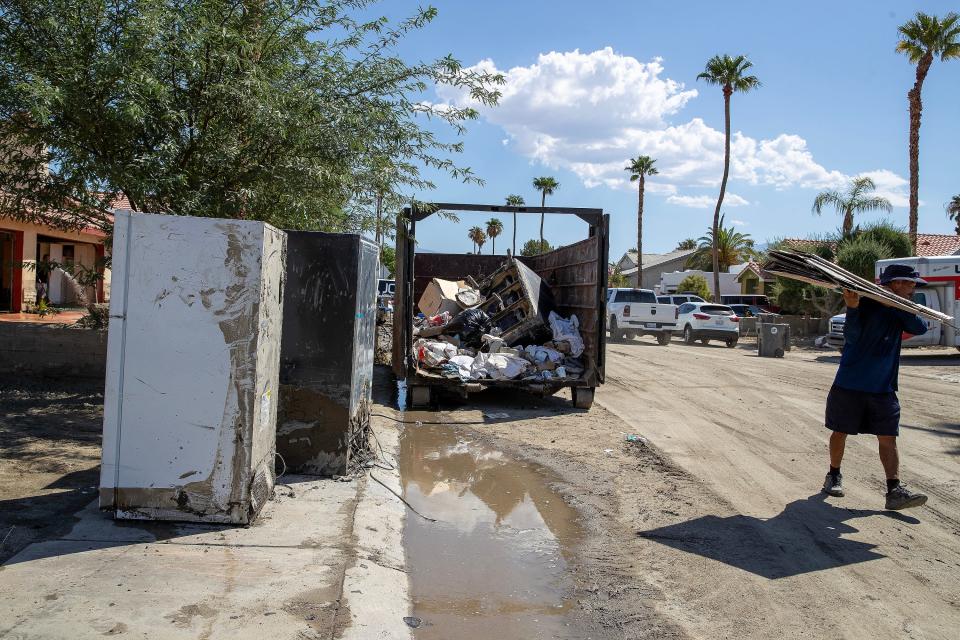
Cathedral City’s efforts in the days after the storm were focused on cleaning mud, and reopening the street so people could get in and out. Volunteers and donations, which include equipment for removing mud, have been instrumental in that process – especially since city staff have not been working inside homes. McClendon said the city's responsibility is public property and it's "a tricky proposition" to use public resources on private property. Instead, volunteers and residents have been moving mud and debris from inside homes to the street for the city to clear.

“We’re really working hard to try to help the residents as much as we can because it’s a monumental task that they have in front of them,” McClendon said.
The city, which has declared a state of emergency, has also requested aid from Riverside County and other resources.
They partnered together to open a local assistance center for residents throughout the valley impacted by the storm. It is located at the Cathedral City Library Community Room on 33-520 Date Palm Drive, and will be open from 9 a.m. to 7 p.m. Sept. 6 through 8.
'Just overwhelming;' Residents continue to deal with the aftermath
May Xu said water and mud were up to her knee in about a minute during the storm. She lived in her house with her boyfriend Michael Sereno, who wasn’t there at the time, and two of her employees.
“I (felt) like something (is puncturing) the garage door, then I go … downstairs and I just see water and mud coming in,” she said.
They all ran upstairs for safety. After several hours of police not coming to rescue them and a gas leak, Sereno came and got everyone out through a window. He said there was around 3 feet of mud when it was wet, which prevented the door from opening.
But after over a week, Sereno said the mud has mostly been removed from inside their home and driveway. He has been going to the house every day from 7 a.m. to sundown so volunteers can get inside.
Now they need to figure out how to get the dirt out of their backyard, he said. Their pool is filled 2 feet over the top.


“(It’s) just overwhelming all the little things we have to start doing, with negotiating with insurance and getting insurance all the pictures,” Sereno said.
Sereno and Xu have been staying at Hotel Zoso, where Xu owns a spa.
“It’s getting to us right now ... (it's) one thing after the other," he said.
Ravanello and his wife have been staying in a friend's RV. He said their insurance should provide them temporary housing soon. Volunteers have been helping remove mud from their property, but he doesn't know yet if his home is going to be repaired or rebuilt.
"It's a whole plethora of emotions that every day is a little bit different and then it's a wave of (somberness) and some tears," he said. "Then you just feel strong and we're gonna get through this."

This article originally appeared on Palm Springs Desert Sun: Tropical Storm Hilary destroyed one Palm Springs area neighborhood. Here's why


