
It’s America’s greatest road-trip route – and you’ve probably never heard of it

The map of America is laced with great routes and pathways – some of them so iconic that their hallowed reputations gleam far beyond the boundaries of the landmass on which they sit. Route 66 is certainly one – a slice of road-trip nirvana whose celebrity is undiminished by the fact that it has not been an official part of the US highway network since 1985. The Overseas Highway through the Florida Keys has a fame which belies the footnote that, prior to 1928, no road between the islands existed. “Highway 1” needs no introduction as California’s thread-the-needle line of tarmac along the Pacific Ocean, even though the USA alone boasts more than 50 other roads that wear the same moniker.
But then there is the Lewis and Clark National Historic Trail – a curious exception to the rule above, in that it is enormously revered within the United States, yet rarely registers more than a flicker of recognition outside American borders. True, it is a snaking series of associated places rather than a heat-haze highway – an “inconvenience” which helps to explain its relative anonymity among foreign observers. But, in total, it is longer, and more dramatic, than any of the drivable ways to explore the USA that attract tourists in their droves. It is also, as a well-thumbed page in the syllabus, as familiar to pupils from San Francisco to South Carolina as the six wives of Henry VIII are to students in the UK.
Its lodging at the forefront of the American mind can partly be explained by raw maths and big numbers. In its near-3,700 miles of stubborn meandering, the trail makes its way through 11 of the 50 states (Illinois, Missouri, Kansas, Iowa, Nebraska, South Dakota, North Dakota, Montana, Idaho, Oregon and Washington). That it does so by cutting across some of the most magnificent aspects of the American landscape – the Great Plains at the heart of the country, the Rocky Mountains which claw fractiously at its skies, the dense forests and rainy demeanour of the upper Pacific states – only adds to its appeal. As such, it is (in non-Covid times) a key to the door that opens onto the Northwest of this vast nation and has been protected as a National Historic Trail since 1978.
Today brings a trail milestone of sorts – the 250th anniversary of the birth (on August 1 1770) of William Clark – one of the co-leaders of the expedition which forged carefully and precariously west (and then back again) between May 1804 and September 1806. Like his colleague Meriwether Lewis, Clark was a jack-of-all-trades of the American 19th century; a soldier, a frontiersman and (later) a politician, as well as a hardy explorer.
Not that exploration was the sole or main purpose of the odyssey with which the two men were tasked by President Thomas Jefferson in the early throes of 1803. In those seismic days, the US was in the process of organising the Louisiana Purchase – the grand transaction which saw it buy a vast swathe of North American territory (from the Gulf Coast and Louisiana in the south-east to what is now Montana and the Canadian province of Alberta in the north-west) from France.
Jefferson was acutely aware that, in effect, this arrangement was only really securing an acknowledgement that a power now under Napoleon’s control would not challenge American incursion into 828,000 square miles of mostly undocumented terrain. It did not guarantee suzerainty over the indigenous tribes who inhabited these remote places with a spirited resistance to invaders, nor that Spain (which had a huge foothold on the continent in the south-west) or Britain (skulking to the north) would not attempt takeovers of their own.
A statement was needed – an endeavour that would go into these “unknown” spaces and, if only symbolically at first, plant the Stars and Stripes in their soil. An expedition would do it. Knowledge would be acquired, charts would be drawn up, the foundations of fledgling political authority would be laid.
Jefferson commissioned the Corps of Discovery – a special unit within the United States Army – to take on the job. Lewis, handed the role of leader, asked his close friend Clark to assist him. The latter set off from Camp Dubois – on the Wood River in present-day Illinois – on May 14 1804; his companion joined him at St Charles in what is now Missouri six days later. Records, sparse, suggest they were accompanied by up to 45 men.
Initially, they would take an “established” route, going upstream along the River Missouri – past the locations where Kansas City and Omaha (the largest metropolis in Nebraska) now stand – to its headwaters in Montana. In doing so, they came into contact with the local population. Notably the Lakota (in what is now South Dakota) – with whom there were several tense stand-offs, but ultimately no outbreaks of violence – and the Mandan.
In the latter case, Lewis and Clark were fortunate. Having built Fort Mandan near what is now Washburn, North Dakota – as a safe haven in which to see out the winter of 1804-05 – they held a series of meetings with Mandan chiefs. It was in one of these that they were introduced to Toussaint Charbonneau, a French-Canadian fur-trapper married to Sacagawea, a Shoshone woman. The couple would join the expedition as translators and negotiators, easing access into what was now land that no white American had ever seen.
It is unclear if the expeditionaries were aware that the Rockies waited in their path. Prior European-American geographical records are sketchy on the existence of the mountains which form North America’s spine. But if Lewis and Clark were not expecting a horizon filled with snow-capped peaks, they learned fast – crossing the Continental Divide via Lemhi Pass on what is now the Montana-Idaho border. From here, the waters took them down – the Clearwater and Snake Rivers, and then the Columbia, all navigated by canoe.
The Columbia at least carried them back onto a map of sorts. In 1792, William Broughton – an officer with the Royal Navy – had ventured up the river as part of the Vancouver Expedition, the British voyage of exploration which gazed in awe on the Pacific coast of North America. Broughton charted the sections of the Columbia which run through what are now Oregon and Washington - and it was his notes on which Lewis and Clark relied as they continued west. With this, of course, they knew that they were nearing the ocean. They sighted it on November 7 1805, and reached it two weeks later, settling down for their second winter at what is now Astoria, where Oregon rubs shoulders with the waves.
If the return leg was not quite the exercise in discovery that the first 18 months had been – encounters with the Blackfeet and Crow tribes; the expedition splitting deliberately into two to follow the Marias and Yellowstone Rivers in separate teams – then it also achieved the success of returning safely, arriving in St Louis on September 23 1806. With this, the gate was open. What followed was, of course, to the considerable detriment of indigenous America, though it also led to the eventual completion of the recognised USA that now haunts the atlas. A continent’s political contours were redefined. The world had changed.
Lewis and Clark's names were not immediately written into American folklore. As the 19th century progressed, their achievement faded to black. Lewis was gone just three years later, dead at the age of 35 in exceptionally murky circumstances – either at his own hand, or as the victim of a robbery which spiralled into murder – in October 1809; Clark became governor of Missouri, but was involved in President Andrew Jackson’s bloody policy of removing Native Americans from their ancestral lands. It would take until the centenary of the expedition – and an exhibition in tribute held in Portland (in Oregon) – for its story to begin its own winding journey into school textbooks. A further century on, it still provides a series of significant stitches to the American tapestry – and even if Covid-19 denies the planet a chance to do so for the next few months, it is a tale which demands closer inspection by those who do not know it. Not least because many of the places in which it happened are very worthy points of interest on any modern road trip.
Five key locations to visit on the Lewis and Clark National Historic Trail…
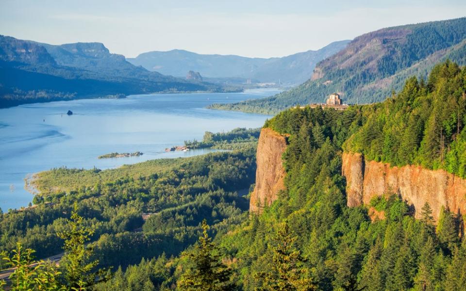
Lewis and Clark National and State Historical Parks (Oregon/Washington)
This wordily titled enclave encompasses the sites, on both sides of the Columbia estuary, where the expedition dug in for the winter of 1805-06 – including a reconstruction of Fort Clatsop (near Astoria, on the Oregon side of the river), the rudimentary wooden structure in which they waited out the coldest months. Ecola State Park (also in Oregon), where the expedition trekked, has since found a different sort of adventurous fame. It was one of the key settings in the creation of 1985’s classic children’s treasure-hunt movie The Goonies.
Details: nps.gov/lewi
Lemhi Pass (Montana/Idaho)
To call the gap in the range via which the expedition crossed the North American spine simply “part of the Rockies” is rather to undersell its significance. Lemhi Pass clings to the Continental Divide – and the Idaho-Montana state line - at an elevation of 7,373ft (2,247m). But even 215 years after Lewis and Clark made their way through it, it can still only be reached via dirt roads. A four-wheel-drive is essential. So are the views at the top.
Sergeant Floyd Monument (Iowa)
The expedition was not without its fatalities. Two Blackfeet men were killed by Lewis’s group in a row on the return leg; Charles Floyd died of a rather more natural cause before the first summer of the expedition was over. He succumbed to appendicitis on August 20 1804, and was buried on the banks of the Missouri. The site is marked by an obelisk (the Sergeant Floyd Monument) in what is inevitably called Floyd’s Bluff in Sioux City, Iowa.
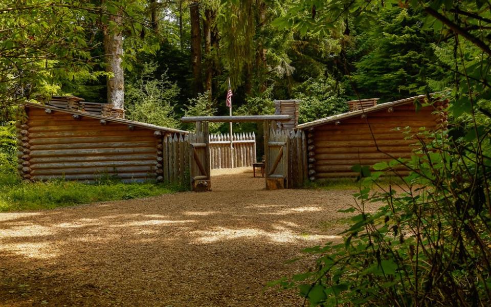
Fort Mandan (North Dakota)
Despite its huge importance to the expedition – it was the place where Lewis and Clark met Charbonneau and Sacagawea – the original Fort Mandan has vanished from view. It should be no surprise that the original structure is gone – it was a temporary wooden shelter set up on the north-east bank of the Missouri. But its exact location has also been lost to posterity – it was probably on what is now private land near Washburn. However, you can visit a reconstruction of the fort, plus an interpretive centre, 10 miles downriver.
Details: nps.gov/fort-mandan; parkrec.nd.gov/lewis-clark-interpretive-center
Nez Perce National Historical Park (Idaho)
On the return leg of their journey, Lewis and Clark halted for roughly a month (mid-May to mid-June 1806) in (what is now) Idaho, biding they time until they judged that the Rockies would be passable. They cooled their boots at Camp Chopunnish, on the north bank of the Clearwater River, on the territory of the Nez Perce (Niimiipuu) people. Two centuries later, the location is part of Nez Perce National Historical Park, which protects 38 sites associated with the tribe in Montana, Oregon and Washington, as well as Idaho.
Details: nps.gov/nepe
And one that you can’t…
Celilo Falls (Oregon)
The expedition’s journey down the Columbia River by canoe forced them to deal with this tumultuous cascade, which made merry in the shadow of Mount Hood. Alas, Celilo Falls no longer exists. What was once an obstacle of significant splash where tribes used to fish – its name, given to it by the indigenous Wyam people, loosely translates as “sound of water on the rocks” – was submerged in 1957, with the construction of the Dalles Dam.

